Complex ground conditions can make the identification of the critical geological factors which control landslides problematic. However, detailed mapping and investigation combined with knowledge of geological materials and geomorphological processes and their engineering implications allow the assessment and identification of these factors. GRS staff have extensive experience in the forensic investigation of catastrophic landslides, including expert witness reports.
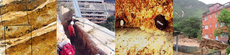
GRS currently provide specialist sub-consultancy services to Fugro URS JV as part of the Hong Kong Government’s 2012-2013 Landslide Investigation Consultancy (LIC). GRS has been a specialist sub-consultant on the LIC since the company formation in 2007. The previous 2008-2009 consultancy involved emergency inspections immediately following an estimated 1 in 1000-year rainstorm event in June 2008, which triggered over 1400 landslides. Following the inspections, engineering geological mapping of selected landslides was undertaken to establish insights into landslide processes and factors such as source volumes, entrainment and debris run out
.
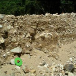
Graded fluvial deposits located 1.8km from the landslide source area indicate that a debris flood event had occurred following a severe rainstorm in June 2008 in Hong Kong. The investigation determined that a 300m³ debris avalanche rapidly developed into a channelised debris flow entraining >5000m³ of material and that the long run out of the debris (>1.8km) was a result of the landslide transforming into a debris flood.
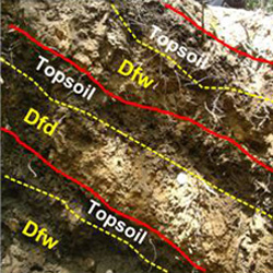
Site investigation and detailed logging allowed the subdivision of “colluvium” into a sequence of debris flow (dfw) and debris flood deposits (dfd). This enabled GRS to re-evaluate the geomorphological processes at the site and to subsequently reduce the design event to be adopted for mitigation works. Parry, S., Hart, J.R. & Moore, A.J. (2009)
GRS staff were involved with several forensic investigations of major slope failures in Hong Kong involving detailed geological and mineralogical studies of the properties and origins of clay-rich zones associated with the failures. The findings were discussed in Parry, S., Campbell, S. D.C. & Churchman, G. J. (2004), “The origin and shear strength of kaolin-rich zones in Hong Kong and their implications for slope stability” in Advances in Geotechnical Engineering. The Skempton Conference. Institute of Civil Engineers. Volume 2, pp 1343-135.
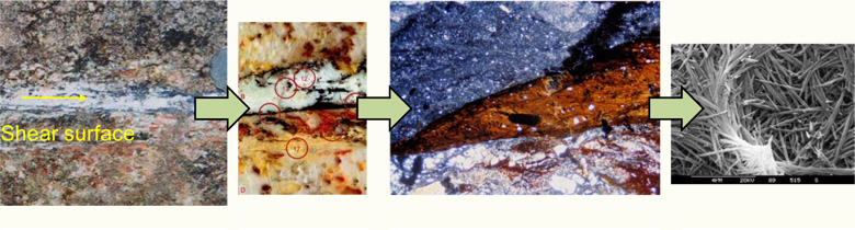
| Kaolin infilled discontinuity (10-15mm thick) within which shearing occurred. This formed the basal shear surface of a 3500m³ landslide |
Resin impregnated thin section (50mm x 75mm) | Optical micrograph (width of view 6.5mm) showing brecciated granite saprolite overlying white kaolin infill. Note manganese stained foliated kaolin at infill boundary suggests previous multiple shearing | Scanning Electron Microscope images showing tubular halloysite (width of view 12µm) |